
Traveling from Pakistan’s capital city, Islamabad, to the breathtaking mountain hub of Gilgit is one of the most iconic road journeys in Asia. Nestled deep in the Karakoram range, Gilgit serves as the ultimate administrative and geographic gateway to Gilgit-Baltistan’s high-altitude valleys, historic silk routes, and massive glaciers.
Whether you are planning a self-drive road trip, taking a passenger bus, or flying into the mountains, understanding the exact route details, distances, and seasonal road closures is essential for a safe and smooth journey.
1. Location and Geographic Overview
-
Starting Point: Islamabad (Capital Territory, Pakistan)
-
Destination: Gilgit City (Administrative Capital of Gilgit-Baltistan)
-
Coordinates: Gilgit is situated at approximately 35.9208° N latitude and 74.3089° E longitude, at an elevation of 1,500 meters (4,900 feet) above sea level.
Gilgit sits at the confluence of the Gilgit River and Hunza River, flanked by the junction of three world-famous mountain ranges: the Himalayas, the Karakorams, and the Hindu Kush.
If you are planning an extended journey north from Gilgit into the land of ancient forts, terraced orchards, and turquoise lakes, exploring Hunza Tour Packages offers an effortless way to extend your road trip through the upper Karakoram Highway toward Attabad Lake and Khunjerab Pass.
2. Distance and Travel Time
-
By Air: Direct distance is approximately 330 km. Flights from Islamabad International Airport (ISB) to Gilgit Airport (GIL) take roughly 1 hour and 15 minutes via PIA ATR aircraft (subject to weather conditions).
-
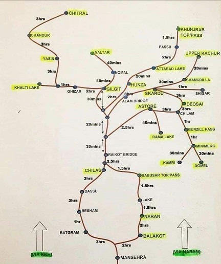
By Road via N-15 (Babusar Top Route): Approximately 510 km to 530 km. Travel time ranges between 11 to 13 hours. (Open seasonally from late June to late October).
-
By Road via N-35 (Karakoram Highway / Besham Route): Approximately 600 km to 620 km. Travel time ranges between 14 to 16 hours. (Open year-round).
3. Road Map and Route Options
There are two primary overland routes connecting Islamabad to Gilgit:
Route A: The Summer Route via N-15 (Hazara Motorway – Naran – Babusar Top – Chilas)
This is the fastest, most picturesque drive during the summer months.
-
Islamabad to Abbottabad/Mansehra: Take the Hazara Motorway (M-15) past Hassan Abdal, Havelian, and Abbottabad to Mansehra.
-
Mansehra to Naran: Follow the N-15 Highway through Balakot, Mahandri, and Kaghan up to Naran Valley.
-
Naran to Babusar Pass: Ascend through Batakundi and Besal to reach Babusar Top (4,173 meters above sea level).
-
Babusar to Chilas: Descend down sharp hairpin curves to hit Zero Point near Chilas.
-
Chilas to Gilgit: Join the Karakoram Highway (N-35) along the Indus River, passing Jaglot to arrive in Gilgit City.
Route B: The Year-Round Route via N-35 (Karakoram Highway via Besham)
When Babusar Pass is closed due to heavy winter snow (November to June), all vehicular traffic routes through the main Karakoram Highway.
-
Islamabad to Thakot: Via the Hazara Motorway (M-15).
-
Thakot to Besham: Follow N-35 along the Indus River bank.
-
Besham to Chilas: Drive through Dasu and Komila.
-
Chilas to Gilgit: Continue on N-35 straight to Gilgit.
4. Connecting Beyond Gilgit to Baltistan
Gilgit is not just a destination; it is the central transit hub of the region. From the Jaglot junction near Gilgit, travelers can branch off onto the newly paved Gilgit-Skardu Road, which winds through dramatic gorges alongside the Indus River.
For travelers seeking to explore the high-altitude Cold Deserts of Katpana, ancient Tibetan architecture, and the plateau of Deosai, booking specialized Skardu Tour Packages allows you to seamlessly combine your Gilgit road trip with a full Baltistan expedition.
5. Travel Tips for Driving from Islamabad to Gilgit
-
Check Weather & Passes: Always confirm whether Babusar Pass is open before selecting the N-15 route.
-
Vehicle Preparation: Ensure your vehicle’s brakes, tires, and cooling systems are inspected. A sedan can travel on both main routes, but high-ground-clearance vehicles offer better comfort over rough patches around Dasu/Chilas.
-
Refueling: Fill up your tank at major hubs like Mansehra, Naran, or Besham, as fuel stations are sparsely located through the mountain gorges.

Leave a Reply